Real-time Display and Tracking of Actual Current (Set & Drift)
One of the nifty capabilities of SailFast is the ability to determine the
actual surface current; both current magnitude and direction. Knowing what the
current is can be helpful in determining the best course to sail. Current
affects the course made good on each tack and the laylines, and therefore is a
factor in your racing tactics.
Often you will be able to adjust your course to sail in more or less current.
Sometimes you can even choose whether to sail in favorable or unfavorable
current, as sometimes happens with Gulf Stream eddies. While sailing in
unfavorable current (current that is slowing you down) by choice is
counterintuitive, it can be the best and fastest course if that course is
shorter or the wind is better. SailFast's optimum routing
algorithms takes this all into account and recommends the fastest course to the
finish or destination, based on the available wind and current grib file
forecasts.
Whether or not you are following an optimum route strategy, there are times when
being able to determine and track the actual current over time and position can
yield a big
competitive advantage. Let's take an example using the Gulf Stream.
Below is a screen shot from SailFast showing a segment of the Gulf Stream. The
color gradient background is the surface water temperature with orange being the
highest temp. The arrows represent the surface current. A black arrow is the
highest current, followed by dark purple, purple and blue. The displayed sea
temp and current are from NOAA RTOFS grib file forecasts. The box in the center
with current and temp values shows the forecasted values at the cursor's position. The
cursor is not shown here but is near the box's top left corner.
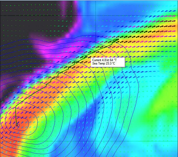
Figure 1. Gulf Stream Segment Optimum Route
The green line shows an optimum route when starting from the waypoint near the
bottom left and assuming you want to get to the upper right waypoint. For this
example the wind is a constant 8 knots 0 degrees true and we are sailing a
Beneteau First 40.7. While this optimum route is great guidance for the
navigator it cannot be blindly followed. In the real
world neither the current nor the wind forecast will exactly match actual
conditions. By observation you will want to determine where the primary flow of
the Gulf Stream is and how current increases or decreases as you move left or
right. There will likely be tradeoffs between maximizing speed over
ground and sailing the shortest distance. With higher winds and boat speed the
current becomes less important and sailing the rhumb line becomes preferred.
Let's use the RTOFS grib model to look at a typical relationship between current
speed and water temperature for a cross section of the Gulf Stream. Using
SailFast's Range/Bearing tool and the cursor data we can easily gather the data
shown in Figure 2. We've arbitrarily defined the edges of the stream at the
current = 2 knots point, and find that the stream width is 38 nm. In this
example current velocity rises quickly as we move into the stream from the North
wall. Initially current increases before hardly any temperature increase is
observed. The current peaks before temperature peaks by a few miles. Note that
the temperature curve has a relatively wide flat top. It would be difficult to
use temperature to find the peak current location. Once sailing on the
temperature flat top it's even hard to determine the direction to more favorable
current. We clearly want to be tracking both current and temperature data.
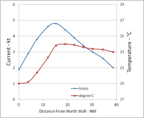
Figure 2. Gulf Stream Cross Section
SailFast is an effective tool for gathering accurate and consistent surface
current data needed to make tactical course decisions.
The simplest way to view the actual current in real-time is to include "Current"
in the Instrument Data display panel. In this example (Figure 3) the current is flowing at
0.9 kt in the direction of 283 degrees magnetic. This is the actual current, not
a forecast from a grib file.
Note that the boat Heading is 207.8 degrees while the COG (course over ground) is 219.1 degrees. The difference is due to the current.
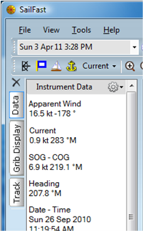
Figure 3.
Figure 4 shows the large number of parameters that can be displayed as Instrument
Data. Some parameters are repeated directly from your GPS or boat instruments
via a NMEA 0183 interface. Other parameters are calculated values, such as
Current, Set and Drift. The parameters most useful in analyzing the effect of
current have been highlighted. "Speed" is the vessel boat speed through the
water; ie. your knot meter reading.
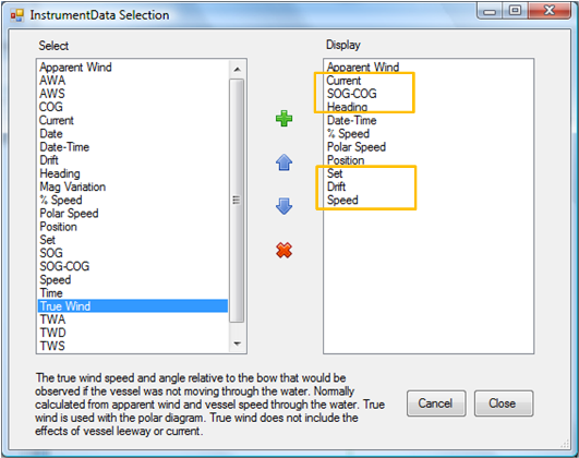
Figure 4. Instrument Data Selection
SailFast can also record any of the available Instrument Data parameters along
the vessel's track as illustrated in Figure 5. In addition, Current can be
periodically displayed as arrows along the track. The arrow color and size
indicates current magnitude just like grib file forecast data.
Active or saved tracks can be evaluated in detail by stepping along a recorded
track and viewing the parameters in the Track Data panel. To learn more about
setting up tracking, refer to the Viewing Active and Saved Tracks section
in the SailFast user manual.
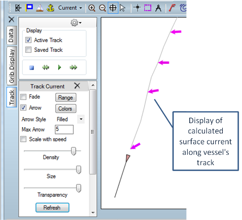
Figure 5. Tracking Current
What Is the Competitive Advantage?
Let's say your navigation decisions result in a 0.5 kt speed advantage over your
competitors during a 6 hour period, while sailing an average of 6 kt. After
sailing 36 nm you will be 3 nm and 30 minutes ahead. A very nice gain!
How Is Current Calculated?
SailFast calculates the actual current in a manner similar to traditional
navigation. If you refer to
The American Practical Navigator (Bowditch), Chapter 7
, you will find a complete discussion. In traditional navigation a course is
sailed and later a position fix (FIX) is made. A corresponding dead reckoning
(DR) position is plotted. Any difference between the FIX and DR positions are
attributed to current set and drift. Set is the current direction and Drift is
the current speed. In reality the FIX and DR difference is not just due to
current but is the combination of all navigation errors and vessel leeway.
Solving for Set and Drift is done by solving a vector triangle, such as the
Figure 6 example.
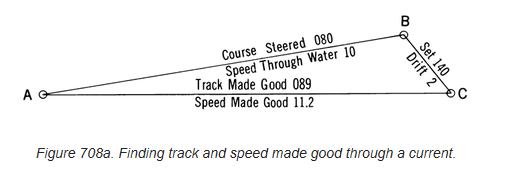
Figure 6. Bowditch - Set and Drift
Traditional navigation requires sailing a significant distance and time to
adequately resolve FIX and DR positions. SailFast does near instantaneous
computations by relying on modern instrumentation. The equivalent vector
triangle uses Heading, Speed, COG and SOG to define the A-B and A-C vectors. The B-C vector
is then solved for Current.
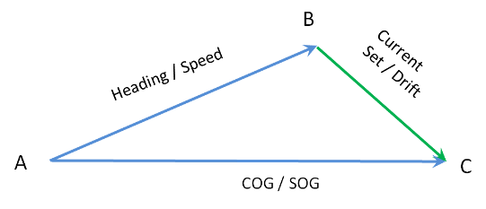
Figure 7. SailFast - Set and Drift
SailFast requires the following NEMA 0183 inputs for current computations.
Be sure that Heading and Speed instruments are well calibrated. Input
errors will directly translate to computed current error.
|
Heading |
Vessel heading in degrees magnetic from the NMEA VHW or HDG sentence. This can
normally be obtained from an auto-pilot. Alternatively a dedicated heading
sensor can be employed.
|
|
Speed |
Vessel speed through the water from NMEA VHW sentence. |
|
COG |
Course over ground from GPS using NMEA RMC sentence. |
|
SOG |
Speed over ground from GPS using NMEA RMC sentence. |
Displayed NMEA data items are filtered to reduce chatter and give more stable
readings. The default filter setting is 5 seconds. Current, Set and Drift data
has an additional default filter setting of 1 minute. The user may modify these
settings on the Options/NMEA tab page.