Products.
Overview
SailFast™ is a PC-based navigation program used to predict optimum routes for offshore racing
and cruising. Weather information is imported directly from Grib forecasts of
wind, current and sea level pressure etc. Support is provided for NOAA's high resolution Gulf of Maine tidal currents (GOMOFS) . These forecasts are not available as Grib files, which means other routing programs can not utilize this tidal data.
Taking into account
vessel speed characteristics and predicted wind and current, SailFast™
determines the fastest course from start to finish, or between any 2 waypoints.
“Isochron” methods are used to find a globally optimized route. A typical
isochron solution from start to finish takes about 3-5 minutes to set up and compute.
SailFast™ predicts
vessel speed using standard polar diagram information. A scalable generic polar
diagram is also included which may be used when the skipper does not have polars
for his boat. Polars for a number of popular boats are also built-in. Various
“what-if” capabilities are included to allow the navigator to explore course and
weather alternatives. SailFast is a powerful tool to assist with the tactical
and strategic decisions that win or lose races.
For the cruiser Sailfast is invaluable for voyage planning and safety. Routing options include avoidance of extreme winds and wave height, and sailing reduced boat speed at night.
Learn what SailFast can do for you, ... download our free
Demo Version (5 day activation).
Also, check out the
Offshore
Race Examples
to learn more.
Specs
- View Grib file weather forecasts for:
Wind (10 meter)
Current, including NOAA RTOFS Gulf Stream
Pressure (Mean Sea Level)
500 mb height
Sea temperature
Rain (accumulated precipitation)
Wave height
Wave height and direction
Wave period
-
NOAA Gulf of Maine Tidal Current (GOMOFS). High res 0.6 NM grid, hourly forecasts out to 72 hours (3 days). The SailFast server converts the GOMOFS NetCDF file format into useable compressed binary for minimum size downloads. (New Version 10.0)
- Easy Grib viewing. Accepts multiple Grib files. No pre-processing required. View both historic and forecast grib data.
-
Directly compare multiple grib models on-screen, such as NOAA GFS and Navy NAVGEM and COAMPS
-
Display a patchwork of mesoscale models and perform optimum routing. You are not restricted to using a single wind Grib file for routing.
-
Tool to create Saildocs Grib file requests. With an internet connection free Grib files may be downloaded directly to your PC without any intermediate email steps. Compatible with Sat phone data link.
-
Active and Saved vessel track display with point by point log of user selected weather and sailing performance data.
-
Use as a local data repeater to view GPS and instrument data, plus ...
% Speed (Actual boat speed compared to polars)
Computed actual current set & drift. Great for the Gulf Stream! See our App Note.
-
Built-in global base map. Optional city name display
-
Sixteen sample boat polars: (8 Added Version 10.3) Archambault A35, Aerodyne38, Aerodyne43, Baltic44_(Asym&Sym), Beneteau First 36.7, Beneteau First 40.7, Beneteau Oceanis 351/352 (WK), Catalina 22, Catalina 36, C&C34-36 XL (WK), C&C 402 (DK), Farr 40, J109, Quest 33, Sabre 362, Sabre 38-2
-
Customize an existing polar or enter your own.
-
Isochron optimum weather routing with time steps from 0.25 to 6 hours.
-
Optimum Route Table: View detailed data for each segment of an optimum route including lat lon, apparent and true wind, heading, boat speed, SOG, COG, and current. It is now easier to follow the suggested routing, plan sail changes and judge actual vs. simulated performance. The table and chart are interactive and synchronized. Highlight a table route segment and the chart will show vessel position and related weather forecast values (wind, current etc.).
-
Print images of SailFast chart and Optimum Route Table.
-
What-If Analysis
User settable sailing boundaries
Alternative course analysis
Manual override of Grib wind or current (temporary, time phased or permanent)
Add/subtract to Grib wind speed and/or direction
Avoid extreme wind
Avoid extreme significant wave height
Run on-engine when wind is light
-
Waypoint Laylines (New Version 10.0)
Port and Starboard layline display (requires NMEA wind sensor, boat speed amd heading)
Layline range over previous 5 and 10 minutes.
Time and distance estimate
Target boat speed, bearing, apparent and true wind angles
Audible notifications on layline approach
-
Range / bearing and Line Of Position drawing tools. (New Version 10.0)
-
Interface to NMEA 0183 GPS and Wind Instrument data (not required for basic optimum routing operation and Grib viewing). Display or log all NMEA data.
-
NMEA 0183 Sentences Supported
DBT (Depth below transducer)
GLL (Lat Lon position when RMC not available)
HDG (Magnetic heading when VHW not available)
MTW (Water temperature)
MWV (Wind speed and angle)
RMC (Minimum recommended GPS data)
VHW (Boat speed through water and magnetic heading)
World Coastline Map
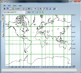
World wide coastline map. Increased detail on zoom in.
Sea Level Pressure
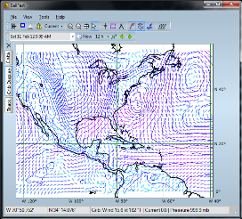
Milli-bars displayed on mouse over. Adjustable isobar contour increments.
Farr 40 Polars
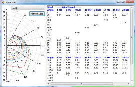
Example of one of the built-in polars. You may customize or scale an existing polar, or input new polars.
Optimum Routing
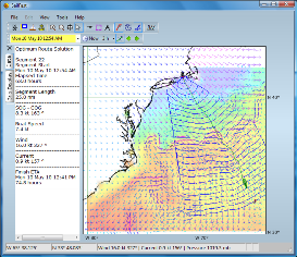
J109 optimum route Newport to Bermuda. Overlayed on forecasted Wind, Current and Sea Temperature
Laylines
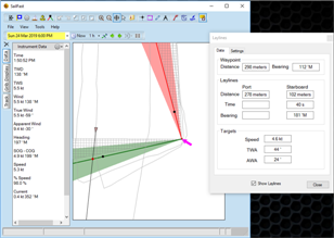
Windward waypoint laylines with ETA and VMG Targets.
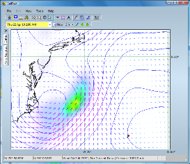
Gulf Stream

Current (arrows) and sea temperature (color gradient). Using NOAA RTOFS grib forecast.
Wind, MSL Pressure & Rain
Rain can often be used to visualize frontal systems. Mouse over to view high and low pressure center values.